TL;DR Summary
- Location: Mount Kursi, Bromo Zone B (Tengger Caldera).
- Difficulty: Extreme Hiking / High-Level Photography.
- Total Duration: 7 Hours.
- Key Highlights: Secluded sunrise, Segoro Wedi Kedol & Lor, crater rim traversal.
- Requirement: Professional guide and specialized gear.
The quest for the ultimate Bromo sunrise often leads to crowded platforms, but the Mount Kursi trekking route offers a silent alternative. By accessing the restricted Bromo Zone B, photographers can capture the Tengger caldera’s majesty without the distraction of thousands of tourists.
At Panorama Lens Trip, our local guides have spent decades navigating these volcanic ridgelines. We believe that the true essence of East Java’s volcanic landscape isn’t found at the popular viewpoints, but along the jagged edges of the crater rim where the wind and the silence tell the story of the earth’s raw power. This guide provides the exact 7-hour blueprint for this extreme expedition.
What Makes Mount Kursi the Most Secluded Sunrise Viewpoint in Mount Bromo?
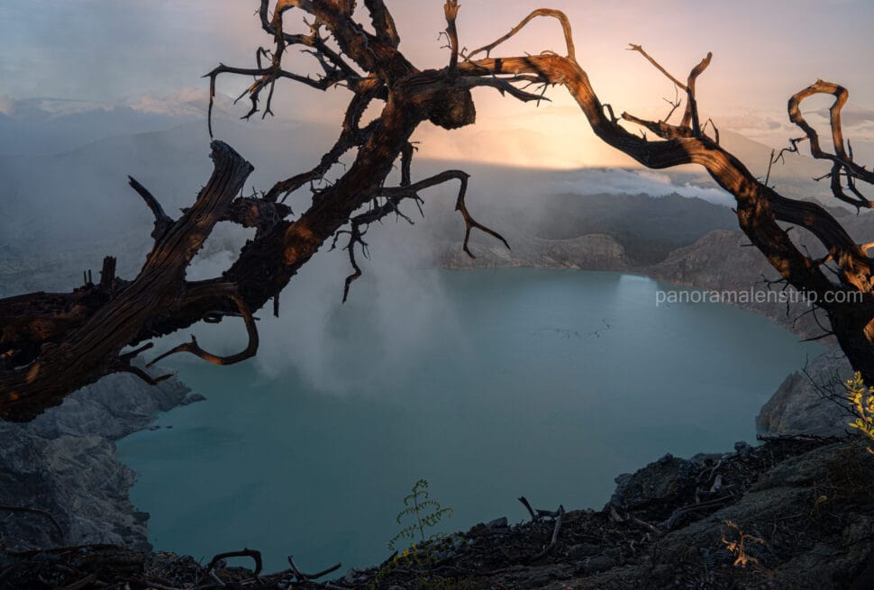
Mount Kursi is Bromo’s most secluded viewpoint because it is located deep within the Tengger caldera’s “Extreme Hiking Zone,” far from the Jeep-accessible platforms. It offers an unobstructed, 360-degree panorama of the active craters and the Segoro Wedi sand seas, catering specifically to professional landscape photographers seeking solitude.
While 95% of visitors congregate at Penanjakan 1 or King Kong Hill, these locations suffer from a shared perspective and significant light pollution from thousands of mobile phones. Mount Kursi, by contrast, sits at a unique elevation and angle within Zone B. Yes, the famous Penanjakan viewpoint offers height, but it lacks the exclusive, crowd-free foreground provided by the Kursi crater rim. From this vantage point, the foreground consists of pristine volcanic ripples and the sheer drop-off into the “Sea of Sand,” rather than the heads of other tourists. This spatial exclusivity allows for low-angle tripod setups and long exposures that are physically impossible at the main public viewpoints.
How Does the Legend Hiking Zone Dictate Your Route Safety?
Safety in Bromo is dictated by four distinct zones that categorize terrain from “Easy” to “Extreme.” Mount Kursi falls within the Extreme Hiking Zone, requiring specialized gear and expert navigation due to its proximity to the active crater rim and the unstable volcanic soils of the Tengger massif.
Navigating the Bromo-Tengger-Semeru National Park requires an understanding of these geological boundaries. The “Extreme Hiking Zone” (Zone B) is characterized by steep gradients, loose volcanic ash, and potential exposure to sulfurous gases depending on wind direction.
| Safety Zone | Risk Level | Required Gear | Guide Necessity |
|---|---|---|---|
| Danger Zone | High (Active Vent) | Gas Mask, Helmet | Prohibited/Strict |
| Extreme Hiking | Moderate-High (Zone B) | Trekking Poles, Boots | Mandatory |
| Mild Tracking | Low (Sand Sea) | Standard Sneakers | Optional |
| Easy Tracking | Negligible (Hotel/Road) | Casual Wear | Not Required |
When Does the Journey Through the Morning Mist Begin?
The journey begins at 3:30 AM with a 4WD Jeep transport from the hotel, followed by a rigorous 1-hour drive through the sand sea. This early departure ensures hikers reach the base of the Mount Kursi ascent before the first light touches the Tengger caldera.
The drive across the caldera floor in total darkness is an experience in itself. The Jeep navigates by the light of its own beams, cutting through the dense morning mist that often settles in the “Segoro Wedi.” This timing is critical; arriving even fifteen minutes late can mean missing the “Blue Hour” transition which is vital for high-end landscape photography.
Step directly into the volcanic landscapes of East Java and visualize your upcoming trek by walking through our latest field video.
How Long Does the Trek Along the Exotic Crater Rim Take?
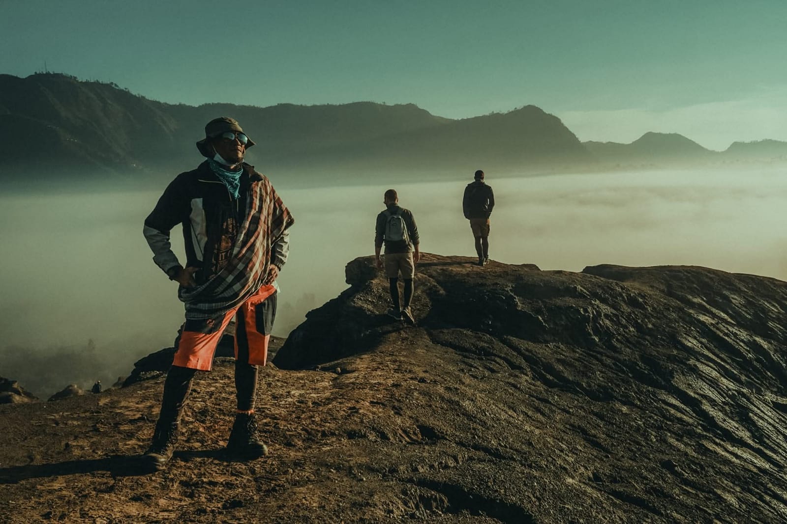
The traversal along the exotic crater rim typically takes 1 hour of focused hiking. This segment involves navigating narrow ridgelines and volcanic scree, offering a dramatic perspective of the active vent on one side and the vast, silent Segoro Wedi on the other.
This portion of the trek is the most physically demanding but also the most rewarding. The path follows the natural curvature of the caldera, providing a shifting perspective of Mount Batok and Mount Bromo. The ground here is composed of “sand and stone” (Segoro Wedi), which can be slippery. Hikers must maintain a steady pace, using the ridgeline to gain elevation toward the Kursi summit.
What is the Magic of Experiencing Sunrise at Mount Kursi?
The sunrise at Mount Kursi is characterized by a 1-hour “golden hour” window where crepuscular rays pierce the morning mist. Unlike crowded spots, here the light interacts with the undisturbed sand ripples of the Segoro Wedi, creating deep shadows and vibrant textures.
As the sun crests the horizon, the light hits the smoke of Mount Semeru in the distance before illuminating the floor of the Bromo caldera. Because you are positioned in Zone B, you see the “shadow side” of the craters first, which provides incredible contrast for black-and-white photography. The 1-hour rest period at the summit allows photographers to swap lenses and capture the changing hues from deep violet to fiery orange without being bumped by crowds.
See exactly what your golden hour shots could look like by exploring our recent exclusive galleries.
Where Can You Witness the Dual Charm of Segoro Wedi Kedol and Lor?
You witness the dual charm of Segoro Wedi Kedol (South) and Lor (North) by descending from the Kursi ridge into the sand seas. The southern section takes 1 hour to explore, followed by another hour traversing the northern expanse, revealing the vast scale of the park.
The “Sea of Sand” is not a uniform desert. Segoro Wedi Kedol (the Southern Sea) features high-fidelity topographic dimensions with undulating dunes that reach heights of 3 to 5 meters, created by the prevailing winds hitting the caldera wall. The textures here are incredibly fine, consisting of microscopic volcanic glass and ash. In contrast, Segoro Wedi Lor (the Northern Sea) is flatter and broader, serving as the massive drainage basin for the caldera. Crossing both allows you to document the geological diversity of the Bromo floor, from the coarse debris near the crater to the wind-swept silt of the southern reaches.
Why is the Return Journey a Masterpiece for Landscape Photography?
The return journey is a photography masterpiece because the high sun angle illuminates the textures of the caldera floor that were hidden in shadow at dawn. The 1-hour walk back to the primary viewpoint allows for clear, high-contrast shots of the active Mount Bromo crater.
“The light at 9:00 AM reveals the true scale of the crater’s raw power,” notes our lead guide. As the mist evaporates, the “Lembah Kaldera” (Caldera Valley) opens up, showing the sharp ridges of the ancient Tengger volcano. This is the best time for wide-angle shots that capture the “volcano within a volcano” phenomenon. The clarity provided by the late morning sun makes the green vegetation on the outer caldera walls pop against the grey volcanic sand.
Which Camera Gear Works Best for Bromo’s Active Crater and Sand Sea?
Optimal gear includes a 16-35mm wide-angle lens for caldera vistas and a 70-200mm telephoto for compression shots of the sand ripples. Use an f/8 to f/11 aperture for maximum depth of field and a circular polarizer to manage the glare off the volcanic sand.
Because of the fine volcanic dust in Zone B, it is highly recommended to use a weather-sealed camera body and avoid changing lenses in the open air. A sturdy tripod is essential for the pre-dawn shots, as the winds on the Kursi rim can be significant.
How Does the 7-Hour Trek Conclude Upon Returning to Civilization?
The 7-hour trek concludes with a final 1-hour Jeep descent from the viewpoint area back to your hotel. This transition from the volcanic wilderness to modern amenities marks the end of the expedition, typically arriving in time for a late breakfast and post-processing sessions.
By the time you return, the thousands of “regular” tourists will have already left the park, leaving the roads clear. This final hour allows for a reflective transition out of the “Extreme Zone” and back into the comfort of the mountain lodges.
Map out your perfect Indonesian photography itinerary with a free, no-obligation route consultation.
Contact us on WhatsApp
Frequently Asked Questions About Mount Kursi Trekking
Is a Professional Guide Mandatory for the Extreme Hiking Zone?
Yes. Bromo Zone B and the Mount Kursi route involve unmarked trails and hazardous volcanic terrain. A professional guide is mandatory for safety, navigation through the morning mist, and ensuring compliance with National Park regulations regarding restricted zones.
What is the Best Time of Year for Photography at Bromo Zone B?
The best time is during the dry season, from April to October. During these months, the skies are clearest, and the “milky way” is often visible before dawn. The sand textures in the Segoro Wedi are also more defined when the volcanic ash is dry and wind-blown.# What is the Ultimate Mount Kursi Trekking Route for a Hidden Bromo Sunrise?
TL;DR Summary:
- Mount Kursi: A secluded 2,581-meter peak offering an exclusive, crowd-free vantage point.
- Bromo Zone B: The challenging, off-the-beaten-path approach required to reach this hidden gem.
- Tengger Caldera: The massive, ancient volcanic basin providing the ultimate dramatic backdrop for landscape photography.
The ultimate Mount Kursi trekking route is a rigorous 7-hour expedition into Bromo Zone B, specifically designed to escape mass tourism and secure unparalleled landscape photography. As local guides at Panorama Lens Trip, we have walked these ridges hundreds of times, providing proof of humanity and authentic local expertise to guarantee you the most pristine, breathtaking angles of the volcanic complex.
This specialized itinerary is not a standard tourist stroll. It is a calculated mission into the raw wilderness of East Java. By turning away from the crowded, paved viewpoints, this trek immerses you deeply into the textural beauty of the volcanic ash, the sprawling sea of sand, and the steep ridges that frame the smoking crater. For serious photographers and adventure seekers, mastering this specific route is the key to unlocking the true, untamed spirit of the Bromo landscape.
What Makes Mount Kursi the Most Secluded Sunrise Viewpoint in Mount Bromo?
Mount Kursi is the most secluded sunrise viewpoint in Mount Bromo because its challenging access via Zone B effectively filters out mass tourism. Standing at 2,581 meters, it offers an uninterrupted, crowd-free vantage point over the caldera, allowing landscape photographers to capture pristine foregrounds without interference from hundreds of tourists.
Yes, the famous Mount Penanjakan viewpoint provides a classic, sweeping panorama of the entire Bromo complex, but it fundamentally lacks the exclusive, crowd-free foreground provided by the Zone B crater rim. At Penanjakan, you are inevitably fighting for tripod space alongside hundreds of other visitors, dealing with stray flashlight beams, noise, and restricted angles. The classic view, while beautiful, has been photographed millions of times from the exact same paved platform.
Mount Kursi offers a dramatic counter-narrative to that standard experience. Because reaching it requires a genuine physical commitment and navigation through rugged terrain, the summit remains a sanctuary for those willing to put in the effort. Here, the foreground is yours to command—featuring dramatic, undulating ridges of volcanic sand and wild flora framing the smoking active crater in the distance. The profound silence at this altitude amplifies the grandeur of the impending dawn. You are not just observing the landscape; you are standing intimately within it, securing unique compositions that the crowds across the caldera will never have the opportunity to shoot.
How Does the Legend Hiking Zone Dictate Your Route Safety?
The Legend Hiking Zone dictates your route safety by categorizing the Tengger caldera’s unpredictable, rugged terrain into four distinct classifications. Because reaching Mount Kursi requires traversing the Extreme Hiking Zone, adhering strictly to these categorized safety protocols determines the necessary gear, pacing, and mandatory local guide assistance required for a secure expedition.
| Safety Zone | Risk Level | Required Gear | Guide Necessity |
|---|---|---|---|
| Danger Zone | Critical | Respirator, Gas Monitor | Strictly Prohibited / Special Permit Only |
| Extreme Hiking Zone | High | Trekking Poles, Headlamp, Grip Boots | Mandatory Professional Guide |
| Mild Tracking | Moderate | Sturdy Shoes, Water Supply | Highly Recommended |
| Easy Tracking | Low | Standard Walking Shoes | Optional |
Understanding this zoning system is the most critical aspect of preparing for your ascent. The Mount Kursi route bypasses the heavily trafficked Easy Tracking areas entirely, pushing immediately into Mild Tracking before escalating into the Extreme Hiking Zone.
In the Extreme Hiking Zone, the margin for error narrows significantly. The paths here are not manicured trails; they are narrow spines of loose volcanic scree with steep drop-offs on either side. The lack of artificial lighting, combined with unpredictable wind gusts carrying abrasive ash, makes navigation treacherous for the uninitiated. Your footwear must feature deep, aggressive treads to grip the shifting earth, while trekking poles become essential tools for maintaining three points of contact on steep inclines.
Furthermore, volcanic gas emissions can shift rapidly depending on atmospheric conditions. This is why attempting the Mount Kursi ascent without a seasoned professional is highly dangerous. A local guide does more than just point the way; they read the micro-climate, assess the stability of the ash pathways, and manage your pace through the Extreme Hiking Zone, ensuring you arrive at the summit safely and with enough energy to capture the impending sunrise.
When Does the Journey Through the Morning Mist Begin?
The journey through the morning mist begins precisely at 3:30 AM with a swift departure from your accommodation. This initial phase involves a crucial 1-hour 4WD jeep drive through the pitch-black sea of sand, positioning you at the remote trailhead of Zone B just before the first light breaks.
Step directly into the volcanic landscapes of East Java and visualize your upcoming trek by walking through our latest field video.
Departing under the cover of absolute darkness is essential for timing the perfect golden hour. The air at 3:30 AM in the Tengger caldera is biting cold, often hovering just above freezing. As your 4WD jeep descends into the massive ancient caldera, you are immediately enveloped by a thick, swirling morning mist. The headlights cut through the fog, revealing only brief flashes of the alien, lunar-like landscape of the vast sand sea.
This one-hour drive is an adventure in itself. The terrain is deeply rutted and shifting, requiring skilled local drivers to navigate the featureless expanse without traditional landmarks. The rumbling engine and the swaying of the jeep build a palpable sense of anticipation. By the time the vehicle finally halts at the desolate Zone B starting point at 4:30 AM, the mist often settles low against the caldera floor, isolating you in a sea of clouds. You step out of the jeep into the freezing, sulfur-tinged air, turn on your headlamp, and prepare to transition from off-road driving to the demanding physical reality of the upward trek.
How Long Does the Trek Along the Exotic Crater Rim Take?
The demanding trek along the exotic crater rim takes approximately one hour of sustained, left-ward traversal. This intense segment forces hikers to navigate steep, narrow pathways composed of loose volcanic ash and gravel, requiring careful footwork and balance as you steadily ascend toward the Mount Kursi summit viewpoint.
This one-hour push is the most physically taxing portion of the entire expedition. With only the beam of your headlamp illuminating the dust kicked up by your boots, you must rely on a slow, rhythmic pace. The trail hugs the contours of the ancient caldera, featuring sharp ascents where the ground frequently slips away beneath your feet. Because you are moving left-ward along an exposed rim, the wind can be bracing, demanding windproof layers and mental resilience.
As the hour progresses, the pitch-black sky begins to soften into a deep, nautical blue. The silhouettes of jagged volcanic peaks slowly emerge from the gloom around you. This one hour of grueling traversal acts as a physical rite of passage. The burn in your calves and the deep, cold breaths of thin air are the exact price of admission required to leave the crowds behind, positioning you perfectly on the edge of the rim just as the horizon begins to crack with the first signs of day.
What is the Magic of Experiencing Sunrise at Mount Kursi?
Experiencing sunrise at Mount Kursi is magical because it rewards you with a dedicated one-hour rest period at the summit, highlighted by striking crepuscular rays piercing the morning mist. This tranquil window allows photographers to meticulously capture the shifting colors across the caldera without the distraction or physical pressure of pushing crowds.
See exactly what your golden hour shots could look like by exploring our recent exclusive galleries.
The magic truly unfolds the moment you drop your pack at the summit. Unlike the frantic atmosphere at other viewpoints, the one-hour rest period here is profoundly peaceful. As the sun breaches the horizon, it projects intense, golden crepuscular rays—often called “God rays”—through the valleys and low-hanging fog of the caldera. The light dramatically highlights the textured, deeply grooved slopes of Mount Bromo and Mount Batok in the distance, creating deep, contrasting shadows that are an absolute dream for landscape photography.
During this hour, the sky transitions through a spectacular palette of deep violet, burning magenta, and vibrant gold. Because you are secluded on Mount Kursi, you have the physical space to set up panoramic tripod sweeps, switch lenses, and experiment with different focal lengths without anyone walking into your frame. You can listen to the distant, deep rumble of Bromo’s active crater and watch the plumes of smoke catch the morning light. It is an intensely private, majestic encounter with one of the most dynamic geological forces on the planet, making every bead of sweat from the dark ascent entirely worthwhile. ## Where Can You Witness the Dual Charm of Segoro Wedi Kedol and Lor?
You can witness the mesmerizing dual charm of Segoro Wedi Kedol and Lor by descending directly into the Tengger caldera. This phase requires a dedicated one-hour trek exploring the expansive southern sea of sand, immediately followed by another hour traversing the contrasting northern expanse of this ancient volcanic basin.
Segoro Wedi, famously known as the Sand Sea, is an expansive 5,250-hectare caldera floor. However, the distinct micro-regions of Kedol (South) and Lor (North) offer wildly different photographic opportunities compared to the heavily trafficked tourist Jeep routes. Segoro Wedi Kedol is characterized by its sweeping, wind-sculpted dunes that stretch for approximately three kilometers toward the southern caldera wall. The topographic dimensions here are dramatic; the dunes can reach elevations of 5 to 15 meters, featuring razor-sharp ridges composed of fine, dark basaltic ash. Because tourist groups rarely enter this southern pocket, the natural ripples created by the high-altitude winds remain pristine and undisturbed by tire tracks, offering flawless minimalist foregrounds.
Moving into Segoro Wedi Lor, the landscape aggressively shifts. This northern traverse introduces a flatter, more compressed surface, scattered with ancient pyroclastic debris, deep fissures, and large volcanic bombs ejected during Bromo’s historical eruptions. The contrast is staggering. While the south gives you soft, undulating textures perfect for shadow play, the north provides a rugged foreground that anchors wide-angle shots of towering Mount Batok and Bromo’s smoking vent. Navigating this two-hour section allows photographers to isolate unique geological textures without the visual clutter of mass tourism. You are essentially walking the floor of a collapsed super-volcano, capturing the raw, untouched ash plains that make the Zone B trekking route a truly elite photographic expedition.
Why is the Return Journey a Masterpiece for Landscape Photography?
The return journey is a masterpiece because the harsh morning shadows disappear, revealing the immense scale of the Tengger caldera under full daylight. This one-hour trek back to the viewpoint provides unparalleled visual clarity, exposing the deep fissures of Bromo’s active crater and the sweeping gradients of the sand seas.
As the sun climbs higher in the Javanese sky, the atmospheric haze that dominates the early morning burns off completely. This shift in lighting transforms the previously moody landscape into a high-contrast, hyper-detailed environment. The deep, jagged ravines carved into the sides of Mount Kursi and Mount Batok become sharply defined against the sky. When you re-ascend toward the rim, you are treated to a completely different perspective than your pre-dawn hike. The vastness of the caldera floor opens up beneath you, offering panoramic vistas that are practically impossible to capture during the golden hour due to intense backlighting.
“There is a profound, almost overwhelming sense of scale when you stand on that ridge under the mid-morning sun; you finally realize you aren’t just looking at a mountain, but walking along the fractured spine of an ancient, breathing world,” shares one of our lead local guides at Panorama Lens Trip.
This emotional payoff translates directly into your imagery. The stark daylight accentuates the rugged topography, allowing you to capture the sheer drop-offs and the textured layers of ash that paint the caldera walls. It is during this final hour of upward hiking that landscape photographers often secure their most technically sharp and compositionally complex wide-angle shots, freezing the raw geological violence of the Tengger massif in time.
Which Camera Gear Works Best for Bromo’s Active Crater and Sand Sea?
For Bromo’s vast sand seas and active crater, a versatile 24-70mm lens is essential, paired with a sturdy travel tripod. Keep your ISO low (100-200), use an aperture of f/8 to f/11 for maximum depth of field, and utilize a polarizing filter to cut through the atmospheric volcanic haze.
The dynamic topography of Zone B requires ultimate adaptability. A wide-angle lens (16-35mm) is highly recommended to capture the sweeping scale of the Segoro Wedi dunes and the overarching caldera walls in a single, dramatic frame. However, a telephoto lens (70-200mm) is equally valuable for compressing the landscape, allowing you to isolate the smoking vent of the active crater or pick out the intricate, wind-blown patterns in the remote sand sea. Because volcanic ash is highly abrasive and pervasive, avoid changing lenses in the open; carrying a dual-camera setup is ideal. For the exposure triangle, fast shutter speeds (1/250s or faster) are necessary if you are shooting hand-held during the windy return hike. For pristine foreground sharpness, stick to base ISO on your tripod and rely on longer exposures to balance the brilliant daylight.
How Does the 7-Hour Trek Conclude Upon Returning to Civilization?
The comprehensive 7-hour trek concludes with a final, one-hour descent from the Mount Kursi ridge back down to your hotel base. This gradual walk transitions you from the extreme, wind-swept volcanic highlands back into the lush, populated edges of the Tengger region, arriving just in time for breakfast.
Leaving the desolate beauty of Zone B behind, the trail softens significantly as you descend below the immediate caldera rim. The fine volcanic dust gives way to high-altitude flora and the familiar sights of local Tenggerese agricultural terraces. This final hour serves as a necessary physical and mental cool-down after the intense exertion of navigating the extreme hiking zones and active crater rims. By the time you reach civilization, usually around 10:30 AM, you will have secured a memory card filled with some of the most exclusive and dramatic landscape photography available in East Java.
Escaping the crowds of Penanjakan and conquering the hidden paths of Mount Kursi is no small feat, but the resulting imagery—completely free of tourist crowds and full of raw geological power—is the ultimate reward for the dedicated photographer.
Map out your perfect Indonesian photography itinerary with a free, no-obligation route consultation: Contact us now!
Frequently Asked Questions About Mount Kursi Trekking
Is a Professional Guide Mandatory for the Extreme Hiking Zone?
Yes, a professional local guide is highly recommended, and practically mandatory, for safely navigating Mount Kursi and Bromo Zone B. This area is classified as an Extreme Hiking Zone, meaning the trails are unmarked, constantly shifting due to unpredictable volcanic activity and weather, and feature steep, hazardous drop-offs along the caldera rim. A knowledgeable guide not only ensures your physical safety through the total darkness of the 3:30 AM departure but also knows the precise micro-locations for the best uncrowded photography angles.
What is the Best Time of Year for Photography at Bromo Zone B?
The optimal time for landscape photography at Bromo Zone B is during the Indonesian dry season, running from April to October. During these months, the skies are generally clear, minimizing the chance of rain ruining your camera gear or obscuring the sunrise. Specifically, July and August offer the crispest atmospheric conditions, leading to those highly sought-after vibrant golden hours and distinct crepuscular rays piercing the morning mist. However, be prepared for near-freezing temperatures before dawn during this peak dry period.