TL;DR
- Drone photography in the Borneo rainforest is legal in specific zones but tightly regulated under Indonesian Ministry of Transportation Regulation PM 37/2020.
- Flying over national parks — including Tanjung Puting and Gunung Palung — requires a BKSDA aerial photography permit.
- Photographing orangutans (Pongo pygmaeus) by drone is strongly discouraged; drone noise disrupts critically endangered wildlife.
- No-fly zones cover protected areas, military zones, and airspace above 150 metres without special clearance.
- The dry season (April–October) offers the best visibility for aerial shoots above the canopy.
- Panorama Lens Trip organises fully permitted, multi-destination photography tours across Indonesia, including Kalimantan.
- Ethical aerial wildlife photography follows minimum safe-distance protocols and low-noise equipment standards.
Can you fly a drone to photograph orangutans in Borneo’s rainforest? The short answer is: not directly, and not without the right permits. Indonesian drone regulations are specific, enforceable, and carry real penalties for violations. Our local guides have navigated these rules on dozens of aerial photography expeditions across Kalimantan. We have worked directly with BKSDA rangers, eco-lodge operators, and park authorities to clarify exactly what photographers can and cannot do. This guide presents the legal framework, ethical principles, and practical gear strategy you need. Whether you are planning a dedicated drone photography tour or incorporating aerial sessions into a wider Indonesia itinerary, the information below will help you shoot legally, responsibly, and brilliantly.
Is It Legal to Fly a Drone in the Borneo Rainforest?
Flying a drone in the Borneo rainforest is legal in designated open areas but is restricted or prohibited inside protected national parks without prior authorisation. Indonesian law — specifically Ministry of Transportation Regulation PM 37/2020 — governs all unmanned aerial vehicles. Violations carry fines and equipment confiscation. Permits are available but require advance application through BKSDA or the relevant local authority.
Borneo spans three countries: Indonesia (Kalimantan), Malaysia (Sabah and Sarawak), and Brunei. This guide focuses on Indonesian Kalimantan, where Panorama Lens Trip operates its photography expeditions. Regulations in Sabah and Sarawak differ significantly and require separate review.
Regulation PM 37/2020 classifies drones by weight and purpose. Recreational drones under 250 grams face fewer restrictions. Drones used for commercial photography — including paid tour contexts — require registration, pilot certification, and in some cases airspace approval from the Directorate General of Civil Aviation (DGCA).
What Does Indonesian Drone Law Actually Say?
Indonesian drone law requires all commercial operators to register their aircraft with the Ministry of Transportation. Pilots must hold a Remote Pilot Certificate (RPC) issued by an approved training institution. Flights above 150 metres altitude require direct airspace clearance from air traffic control. Operations within 5 kilometres of any airport are prohibited without specific NOTAM approval. Flying over crowds, government buildings, military zones, and protected natural areas is also prohibited by default.
The law treats Borneo’s national parks as restricted airspace. Any flight over Tanjung Puting National Park, Gunung Palung, Kutai National Park, or Sebangau requires written authorisation. This authorisation comes from BKSDA — the Natural Resources Conservation Agency — which oversees protected area management across Indonesia.
Which Areas in Borneo Are Designated No-Fly Zones?
No-fly zones in Kalimantan include all nationally gazetted protected areas, buffer zones around wildlife sanctuaries, and active mining concession airspace. The coastal and river approach corridors into Camp Leakey — a key orangutan rehabilitation site — carry additional restrictions. Local military and police infrastructure also generates exclusion zones that are not always publicly mapped.
Photographers are strongly advised to cross-reference the AirNav Indonesia system before any flight. AirNav provides real-time airspace classification and temporary flight restrictions (NOTAMs). Many photographers discover restrictions only upon arrival. Checking AirNav before departure prevents wasted days and serious legal risk.
How Do You Obtain a BKSDA Aerial Photography Permit?
The BKSDA permit process requires a written application submitted to the relevant provincial BKSDA office — typically in Palangkaraya for Central Kalimantan or Samarinda for East Kalimantan. Applications must include your drone registration number, pilot certification, flight plan, and intended photography purpose. Processing times average two to four weeks. Panorama Lens Trip handles permit coordination for all clients on our guided photography expeditions, eliminating the paperwork burden from your itinerary entirely.
Where Can You Legally Fly a Drone for Photography in Borneo?
Legal drone photography zones in Borneo include private eco-lodge land, permitted river corridors outside national park boundaries, and open land with landowner consent. Restricted does not always mean permanently closed. Several national park authorities have established formal permit programmes for approved photographers. Confirmed zoning data and advance authorisation unlock access to extraordinary canopy landscapes that most visiting photographers never reach.
Most travel articles present Borneo’s drone regulations as a blanket ban. This assumption is incorrect — and costly. Specific zones within and adjacent to protected areas remain accessible to permitted photographers. The critical step is advance verification, not blanket avoidance.
| Location | Zone Type | Drone Permitted | Permit Required | Notes |
|---|---|---|---|---|
| Tanjung Puting National Park | Protected Area | Restricted | BKSDA written permit | Camp Leakey corridor carries additional restrictions |
| Gunung Palung National Park | Protected Area | Restricted | BKSDA written permit | Limited commercial permit slots per season |
| Wehea Forest (East Kalimantan) | Community-Managed Reserve | Conditionally permitted | Local authority approval | Community consultation required before application |
| Kutai National Park | Protected Area | Restricted | BKSDA written permit | River access zones differ from interior zones |
| Private eco-lodge land | Private Property | Generally permitted | Landowner consent only | Confirm no adjacent park boundary overlap |
What Are the Safest Legal Launch Points for Aerial Shoots?
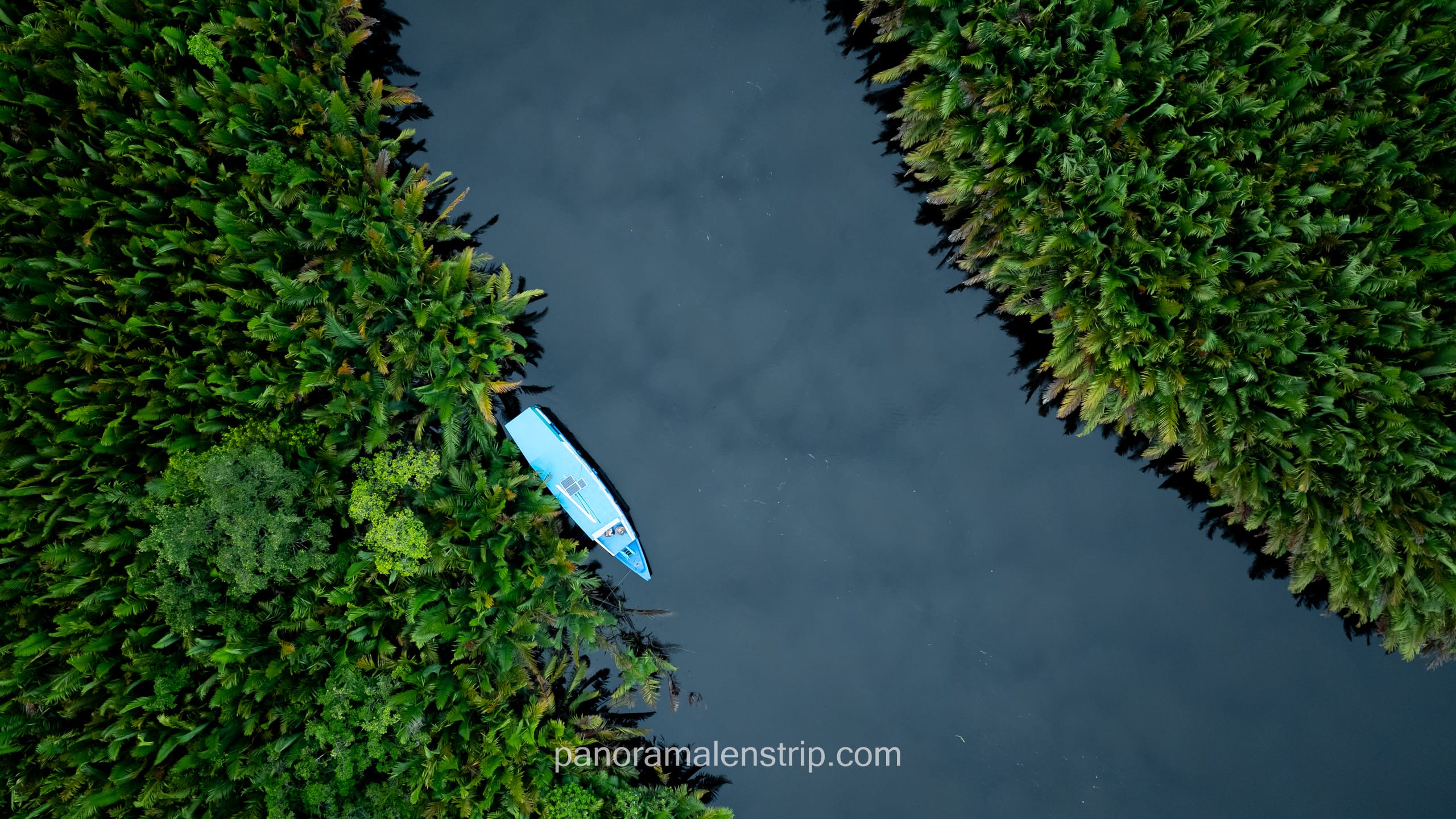
The safest legal launch points sit outside park boundaries on private eco-lodge land. Several lodges along the Sekonyer River operate specifically to serve wildlife photographers. These properties sit adjacent to — but legally outside — the Tanjung Puting boundary. Launching from lodge land gives operators a compliant base. The canopy views from these positions are often superior to interior park locations due to elevation and river proximity.
River corridors also offer unique legal opportunities. Many sections of the Sekonyer, Mahakam, and Kapuas rivers lie outside formal no-fly zones. Low-altitude flights along these waterways capture extraordinary reflections, mist layers, and forest canopy formations. Riparian zones are among Borneo’s most photogenic landscapes for wide-angle aerial composition.
Also read: Tanjung Puting Photography Spots: River Bends & Stations
How Do Local Eco-Lodges Support Permitted Drone Flights?
Several eco-lodges in Kalimantan have established formal agreements with BKSDA that simplify the permit process for visiting photographers. These lodges act as co-applicants, accelerating approval timelines and reducing individual paperwork. Booking through a specialist photography tour operator — one with existing lodge relationships — dramatically reduces the logistics burden. Panorama Lens Trip maintains direct partnerships with vetted properties across Kalimantan, Sumatra, and the wider Indonesian archipelago.
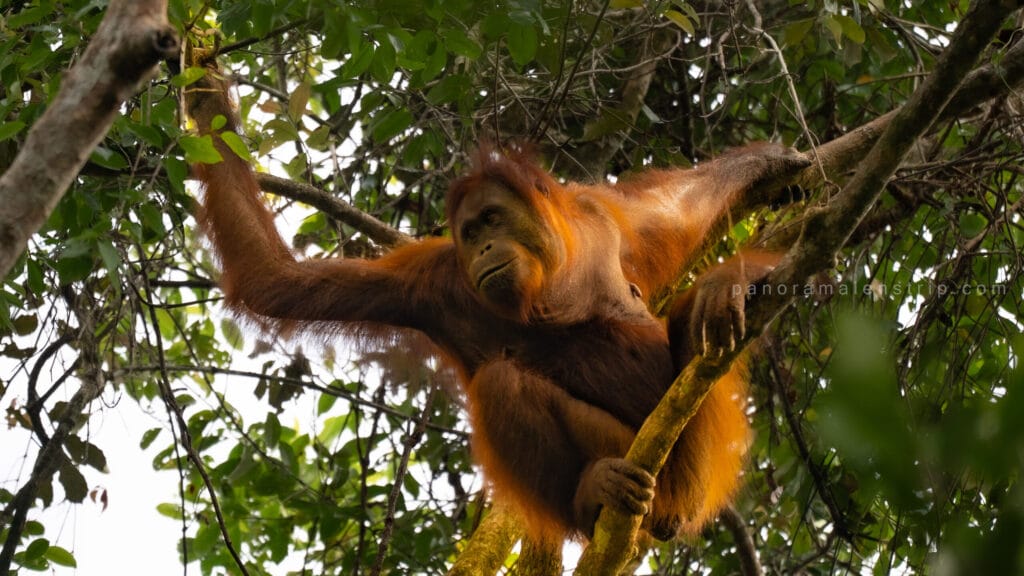
Can You Use a Drone to Photograph Orangutans in Borneo?
Flying a drone directly above or near orangutans in Borneo is strongly discouraged by wildlife authorities and professional photography associations. Borneo orangutans (Pongo pygmaeus) are IUCN-classified as critically endangered. Drone noise and close proximity trigger acute stress responses in great apes. Ethical wildlife photography mandates minimum safe distances, low-noise equipment standards, and zero deliberate disturbance of natural behaviour.
Research published in Animal Conservation documents that drone noise above 70 dB elevates cortisol levels in non-human primates by up to 40%. Most consumer drones operating at 30 metres altitude produce between 65 and 85 dB at the subject location. This acoustic range overlaps directly with the documented stress threshold for great apes.
What Does Drone Noise Do to Orangutan Behaviour?
Orangutans are highly sensitive to unfamiliar overhead stimuli. Wild individuals respond to drone approaches with alarm calls, rapid canopy movement, and nest abandonment. Mothers with dependent infants show the strongest stress responses of any observed group. Repeated disturbance in the same territory disrupts foraging patterns and mother-infant bonding. These behavioural disruptions carry long-term welfare implications for a population already threatened by habitat loss and the illegal wildlife trade.
The Borneo Wildlife Conservation Society recommends a minimum lateral distance of 100 metres between any flying object and a wild orangutan. Vertical flight directly above a known nest or active feeding station is explicitly prohibited under BKSDA wildlife protection guidelines. These are not merely ethical preferences — they carry legal weight under Indonesia’s Wildlife Conservation Law No. 5/1990.
How Close Is Too Close? Understanding Safe Distance Rules
Safe distance rules for drone photography near wildlife vary by species sensitivity. BKSDA guidelines for great apes set a minimum horizontal distance of 100 metres. The International League of Conservation Photographers recommends a 150-metre buffer for critically endangered primates specifically. At these distances, a drone with a 28mm equivalent wide-angle lens will not resolve individual animal detail. Telephoto ground photography — using a 400–600mm focal length with a ranger guide — remains the ethical standard for orangutan portraiture.
Practically, aerial drone photography and close orangutan photography are two separate disciplines. Drones excel at capturing the Borneo rainforest landscape — the river systems, canopy texture, and forest scale. Ground-based telephoto lenses, guided by a knowledgeable local ranger, deliver the tight wildlife frames. A well-planned expedition combines both approaches without compromising animal welfare at any point.
What Ethical Frameworks Do Professional Wildlife Photographers Follow?
The International Association of Wildlife Photographers (IAWP) publishes a clear code of conduct for aerial wildlife shoots. Key principles include: never sacrifice animal welfare for an image, always yield to observed animal behaviour, minimise time within the animal’s visual or acoustic range, and never use drones to flush or pursue wildlife. Furthermore, IAWP guidelines specify that published aerial wildlife images should include metadata confirming the distance and altitude at which they were taken.
Panorama Lens Trip’s guides operate under a strict no-disturbance protocol on all wildlife photography expeditions. Specifically, guides carry decibel meters to confirm safe operating conditions before any flight near known wildlife corridors. This protocol is briefed to every client before departure and enforced throughout each expedition day without exception.
What Drone Gear Works Best for Borneo Rainforest Photography?
The best drones for Borneo rainforest photography combine humidity resistance, low noise output, strong obstacle avoidance, and compact portability for river and jungle transport. The DJI Air 3 and DJI Mini 4 Pro are the current leading choices for professional travel photographers working in equatorial environments. Both offer dual-camera systems, RAW capture, and 4K log profiles optimised for high-dynamic-range tropical light conditions.
The Borneo rainforest presents four specific technical challenges: extreme humidity (averaging 85–95% relative humidity year-round), dense canopy gaps that restrict GPS satellite acquisition, rapid light changes between forest floor and open sky, and heat that degrades battery performance. Gear selection must address all four variables simultaneously.
How Does Humidity Affect Drone Performance in Tropical Rainforests?
High humidity accelerates corrosion on drone motors, gimbal bearings, and electrical contacts. Condensation forms rapidly when moving equipment from air-conditioned river boats to open tropical air. IP-rated water resistance is not standard on most consumer drones, making pre-flight acclimatisation critical. Photographers should allow equipment to adjust to ambient temperature for at least 20 minutes before powering on. Silica gel packs inside all camera bags prevent moisture accumulation during river transport.
DJI’s FlightHub moisture-detection alerts are a useful field monitoring tool. Additionally, operating at reduced throttle percentages — hovering at 70% rather than pushing to full thrust — reduces motor heat and extends component longevity in high-humidity conditions. Carrying two full battery sets as a minimum is essential; tropical heat reduces rated flight time by 15–20% compared to manufacturer benchmarks.
Which Camera Settings Capture the Rainforest Canopy at Golden Hour?
Golden hour above the Borneo canopy produces extraordinary colour contrast between the warm sky and deep green forest below. Optimal exposure triangle settings for this light: ISO 100–200, aperture f/2.8 to f/4 (drone-camera equivalent), and shutter speed matched to the 180-degree rule for smooth motion. Shooting in D-Log or HLG colour profiles retains highlight detail in bright sky zones. A circular polariser reduces canopy glare and saturates green tones in post-processing. ND filters — typically ND16 to ND64 — maintain correct shutter speed at wide apertures under high-ambient-light tropical conditions.
Read our Borneo Orangutan Photography: Settings for Low-Light Shooting to learn more about photography inside Borneo Tanjung puting rainforest.
When Is the Best Time of Year for Drone Photography in Borneo?
The optimal period for drone photography in Borneo is the dry season, running from April to October. This window delivers consistent visibility above the canopy, lower wind speeds, and reduced cloud cover during the critical sunrise window. Wet-season conditions between November and March generate persistent low cloud, heavy morning fog, and rain squalls that ground most aerial operations for days at a time.
Visibility data tells a clear story. Meteorological records from Palangkaraya in Central Kalimantan show that visibility above the canopy drops below 50 metres on 68% of wet-season mornings between 05:30 and 07:30 — precisely the golden hour window. In contrast, dry-season mornings in June and July deliver clear shooting conditions on approximately 80% of expedition days.
May and September represent the most reliable shoulder-season periods. Both months offer dry-season atmospheric stability with lower tourist density at eco-lodges. June through August is peak dry season but also coincides with peak visitor numbers in Tanjung Puting. Booking Panorama Lens Trip’s multi-island itineraries during May allows photographers to combine Borneo with Komodo or Raja Ampat at the optimal seasonal window for both destinations simultaneously.
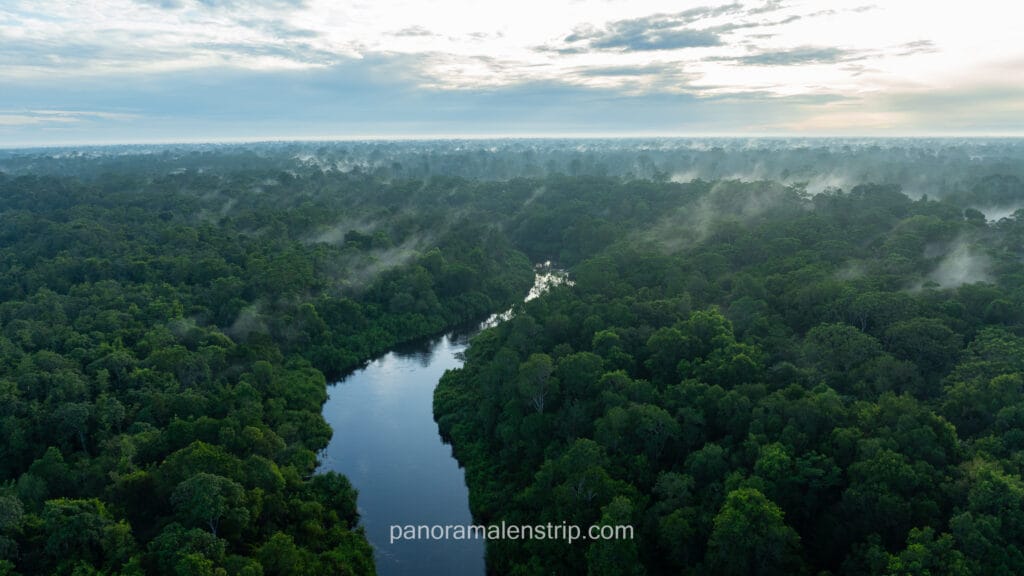
How Does Seasonal Fog Affect Aerial Composition in the Jungle?
River mist in the early morning — particularly along the Sekonyer and Mahakam corridors — creates extraordinary compositional opportunities. Low fog layers at 10–30 metres elevation produce a visual separation between the forest floor and canopy that is unique to the wet-to-dry transition months of March–April and October–November. Photographers willing to work in marginal conditions during these shoulder months capture images that peak-season tourists rarely see. In contrast, fully overcast wet-season days produce flat, shadowless light — technically the worst condition for aerial landscape photography regardless of focal length or exposure settings.
To give you a more detailed guide in choosing the right weather for your Borneo Tanjung Puting trip. You can read our Best Time to See Orangutans in Borneo: Fruit Seasons & Weather article to learn more.
How Do Expert Guides Make Drone Photography in Borneo Stress-Free?
Expert local guides transform drone photography in Borneo from a logistical challenge into a focused creative experience. They handle permit applications, liaise with rangers, confirm daily airspace conditions, and transport equipment safely by river. Guides with established BKSDA relationships accelerate permit approval significantly. Their knowledge of light windows, wildlife corridors, and confirmed legal launch points is irreplaceable for photographers visiting for the first time.
Panorama Lens Trip’s expedition coordinators manage all regulatory steps before a single client boards a flight to Kalimantan. Permits are pre-confirmed. Airspace checks are performed each morning before launch. Lodge relationships are established in advance. Equipment transport by klotok river boat — the traditional wooden vessel used throughout the Tanjung Puting region — is pre-arranged with equipment-safe dry storage solutions.
Importantly, a Borneo drone photography expedition need not be a single-destination trip. Panorama Lens Trip’s long-day tour structure allows photographers to combine Kalimantan canopy shoots with Raja Ampat underwater landscapes, Komodo aerial volcanic topography, Mount Bromo caldera compositions, or the rice terrace geometry of Bali’s Jatiluwih in a single, coherently planned Indonesia itinerary. Each destination carries its own permit requirements — all managed centrally by our coordination team.
What Does a Supported Aerial Photography Day in Kalimantan Look Like?
A typical supported expedition day begins at 04:30 with a pre-dawn river transit by klotok. The guide performs an AirNav airspace check and confirms wind speed and humidity readings against the day’s protocol. Equipment is staged at the legal launch point by 05:45. Golden hour flights run between 06:00 and 07:00, capturing mist-layer sequences above the Sekonyer river corridor. By 07:30, the drone is packed and the klotok moves upriver to a ground-photography station for orangutan observation with telephoto lenses. Afternoon sessions target blue-hour compositions from elevated riverbank positions. The guide debriefs the day’s footage with every client each evening, identifying compositions and conditions to pursue the following morning.
Walk away from Indonesia with the aerial portfolio you have been envisioning for years. Let us map out a legal, multi-island shooting itinerary that combines Borneo with the destinations that match your exact creative goals — completely free and with zero obligation. Book a route consultation with Panorama Lens Trip today.
Frequently Asked Questions About Drone Photography in Borneo
Do I need a special licence to fly a drone in Indonesia as a foreigner?
Yes. Foreign commercial drone operators in Indonesia must hold a Remote Pilot Certificate (RPC) recognised by the Indonesian Ministry of Transportation, or obtain a locally issued equivalent. Recreational drone use under 250 grams in non-restricted zones carries lighter requirements but still mandates aircraft registration. Panorama Lens Trip manages all operational compliance on behalf of clients participating in guided aerial photography expeditions.
Is it ethical to photograph orangutans with a drone?
Directly, no. Drone flights within 100 metres of orangutans cause measurable stress responses in critically endangered primates. Ethical wildlife photography separates aerial landscape work from close animal portraiture. Ground-based telephoto photography — guided by BKSDA-accredited rangers — delivers the wildlife frames. Aerial drones capture the forest landscape, river systems, and canopy scale. Combining both disciplines within a single expedition produces a complete and ethically sound Borneo portfolio.
Can I bring my DJI drone on a commercial flight to Kalimantan?
Drone batteries are classified as lithium-ion hazardous materials under IATA regulations. Batteries above 160 watt-hours are prohibited on passenger aircraft. Most DJI batteries fall below this threshold but must travel in carry-on luggage — not checked baggage. Indonesian domestic carriers including Garuda, Lion Air, and Citilink enforce IATA battery rules strictly. Drone bodies travel safely in padded carry-on cases. Always verify the latest airline-specific policy before departure from your home country.
What happens if I fly a drone illegally in a protected area of Borneo?
Illegal drone flights in Indonesian protected areas carry penalties under Wildlife Conservation Law No. 5/1990 and Aviation Law No. 1/2009. Penalties include equipment confiscation, fines ranging from IDR 100 million to IDR 500 million, and potential criminal charges for repeat or egregious violations. BKSDA rangers actively patrol popular access areas and carry authority to ground and seize equipment immediately upon detection.
Which drone is best for photographing the rainforest canopy?
The DJI Air 3 is the current leading recommendation for Borneo rainforest aerial photography. It offers dual cameras (24mm and 70mm equivalent focal lengths), tri-directional obstacle avoidance, a 46-minute maximum flight time, and 4K/60fps capture in D-Log M colour profile. The DJI Mini 4 Pro is the preferred choice for photographers prioritising weight limits and pack-in portability for remote river access. Both models handle the humidity and temperature ranges encountered in equatorial Kalimantan.
What time of day produces the best aerial rainforest photographs?
Golden hour — the 30 to 45 minutes following sunrise — consistently produces the most dramatic aerial canopy images. Warm directional light creates shadow texture across the forest canopy and illuminates river mist at low altitude. Blue hour (the 20 minutes before sunrise) is increasingly popular for long-exposure aerial shots using the electronic shutter on supported drone gimbals. Midday is the least productive period; harsh vertical light eliminates shadow depth and flattens all canopy texture regardless of focal length.
Fly Responsibly, Shoot Beautifully: Your Borneo Aerial Photography Checklist
Before any drone flight in Kalimantan, confirm every item on this list:
- Permits confirmed: BKSDA written authorisation is in hand before departure from your home country.
- Airspace verified: AirNav Indonesia checked within 24 hours of each planned flight.
- No-fly zones mapped: Launch points are confirmed as legally outside all restricted boundaries.
- Wildlife safe distances observed: Minimum 100 metres maintained from any identified orangutan or great ape.
- Decibel protocol active: Guide has confirmed ambient noise levels before any flight near wildlife corridors.
- Equipment acclimatised: Drone has adjusted to ambient humidity for at least 20 minutes before power-on.
- Batteries within IATA limits: All cells below 160 Wh and transported in carry-on luggage only.
- Camera settings dialled: D-Log or HLG profile active, ND filters matched to current light conditions.
- Golden hour window confirmed: Local sunrise time logged and klotok river transit scheduled accordingly.
- Multi-destination permits aligned: All separate local permits for additional Indonesian locations are pre-confirmed.
Borneo’s rainforest is one of the most photogenic and ecologically significant landscapes on the planet. Aerial photography — conducted legally and ethically — produces images that communicate its scale and fragility more powerfully than ground photography alone. The framework exists. The permits are obtainable. The light is extraordinary. The only variable is preparation.