TL;DR Summary: Mount Batok trekking in Bromo Zone D offers an exclusive 7-hour expedition for photographers seeking dramatic sunset panoramas. Skip the crowded sunrise viewpoints and conquer this dormant volcano’s steep trails to capture golden hour shots of the massive caldera and iconic Mount Bromo without the typical tourist interruptions.
If you want to capture the Tengger caldera’s vast landscapes without fighting through thousands of tourists at Mount Penanjakan, Mount Batok is your ultimate destination. Our local guides analyzed the crowd patterns and lighting conditions across the national park to develop this specialized Mount Batok trekking itinerary. By shifting the focus from the traditional sunrise rush to a majestic sunset ascent in Zone D, photographers gain unimpeded access to one of Indonesia’s most striking volcanic formations. This guide breaks down exactly how to navigate the rugged trails, manage your timeline, and pack the optimal gear to guarantee stunning, wide-angle shots of the entire Bromo basin under the fiery late-afternoon sky.
Is Mount Batok Open for Hiking and Sunset Photography?
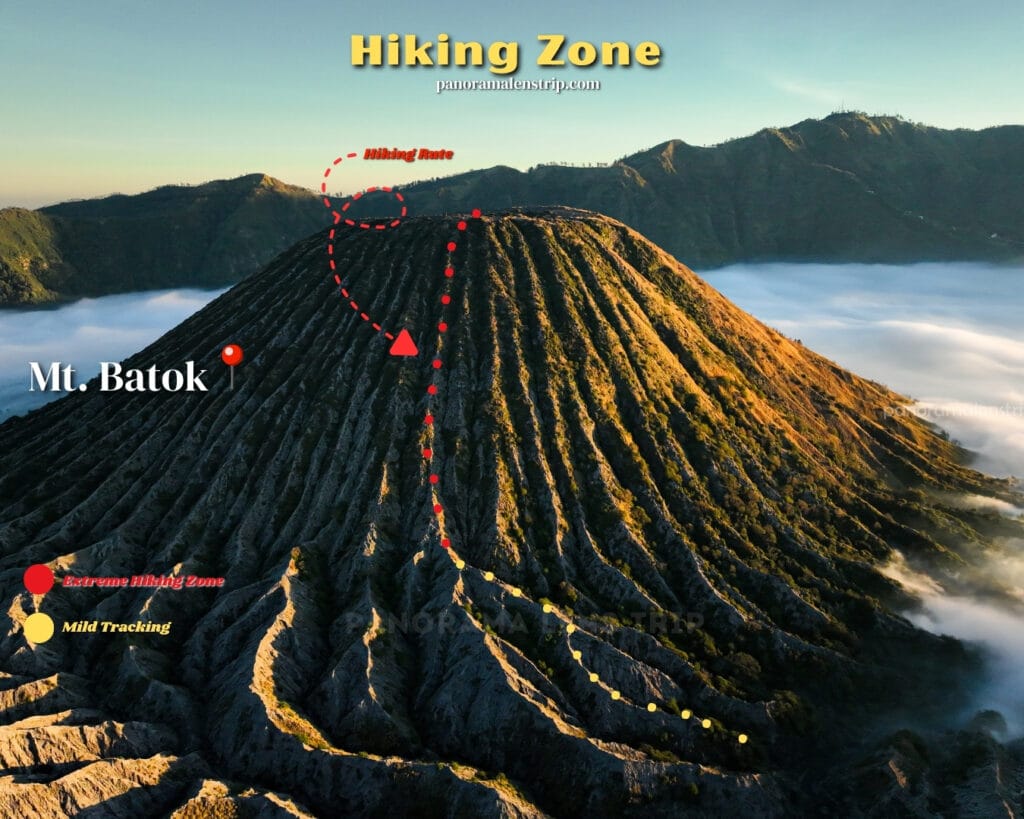
Yes, Mount Batok is fully open for trekking and sunset photography within Bromo Tengger Semeru National Park’s designated Zone D. Visitors can legally hike the dormant 2,440-meter peak, provided they hold a valid park entrance ticket and follow the established trails leading from the Sea of Sand.
Unlike the restricted zones immediately surrounding the active Mount Bromo crater during periods of high seismic activity, Mount Batok remains entirely accessible and safe for hikers year-round. Because it is a dormant cinder cone, it does not emit toxic sulfuric gases, making it an ideal elevated platform for prolonged photography sessions. Local park rangers actively maintain the Zone D parameters to ensure environmental protection, so sticking to the marked paths is mandatory. Since the vast majority of guided tours operate between 3:00 AM and 9:00 AM, the trails up Mount Batok are practically deserted by the late afternoon. This unrestricted afternoon access allows dedicated landscape photographers to explore the ridges freely, setting up tripods and framing complex panoramic shots without the pressure of moving crowds or tight tour schedules.
Why Choose Zone D for Mount Batok Trekking Over Traditional Routes?
There is a pervasive myth in East Java tourism that Mount Bromo is strictly a sunrise destination. This assumption leaves the park’s most dramatic lighting window completely ignored by the masses. Choosing Zone D for Mount Batok trekking flips this outdated script, offering an unparalleled counter-narrative to the typical tourist experience. Instead of standing shoulder-to-shoulder with thousands of people at the traditional viewpoints in the freezing pre-dawn dark, you get an entire dormant volcano practically to yourself.
Zone D strategically positions you directly in the center of the caldera, rather than looking down on it from the distant outer rim. When golden hour strikes, the descending sun casts aggressive, elongated shadows across the Sea of Sand, highlighting the deep, textured ridges of Mount Bromo and Mount Batok in ways sunrise lighting simply cannot replicate. The late afternoon light filters through the lingering atmospheric dust, creating a warm, dimensional glow that is a dream for any wide-angle lens. Furthermore, the sheer physical proximity to the surrounding peaks from Zone D means you aren’t just observing the landscape; you are immersed within it. This central vantage point allows you to shoot 360-degree compositions of the entire caldera, making it the absolute most advantageous location for professionals who demand unique, high-impact travel photography devoid of visual clutter.
What Are the Topography and Trail Conditions?
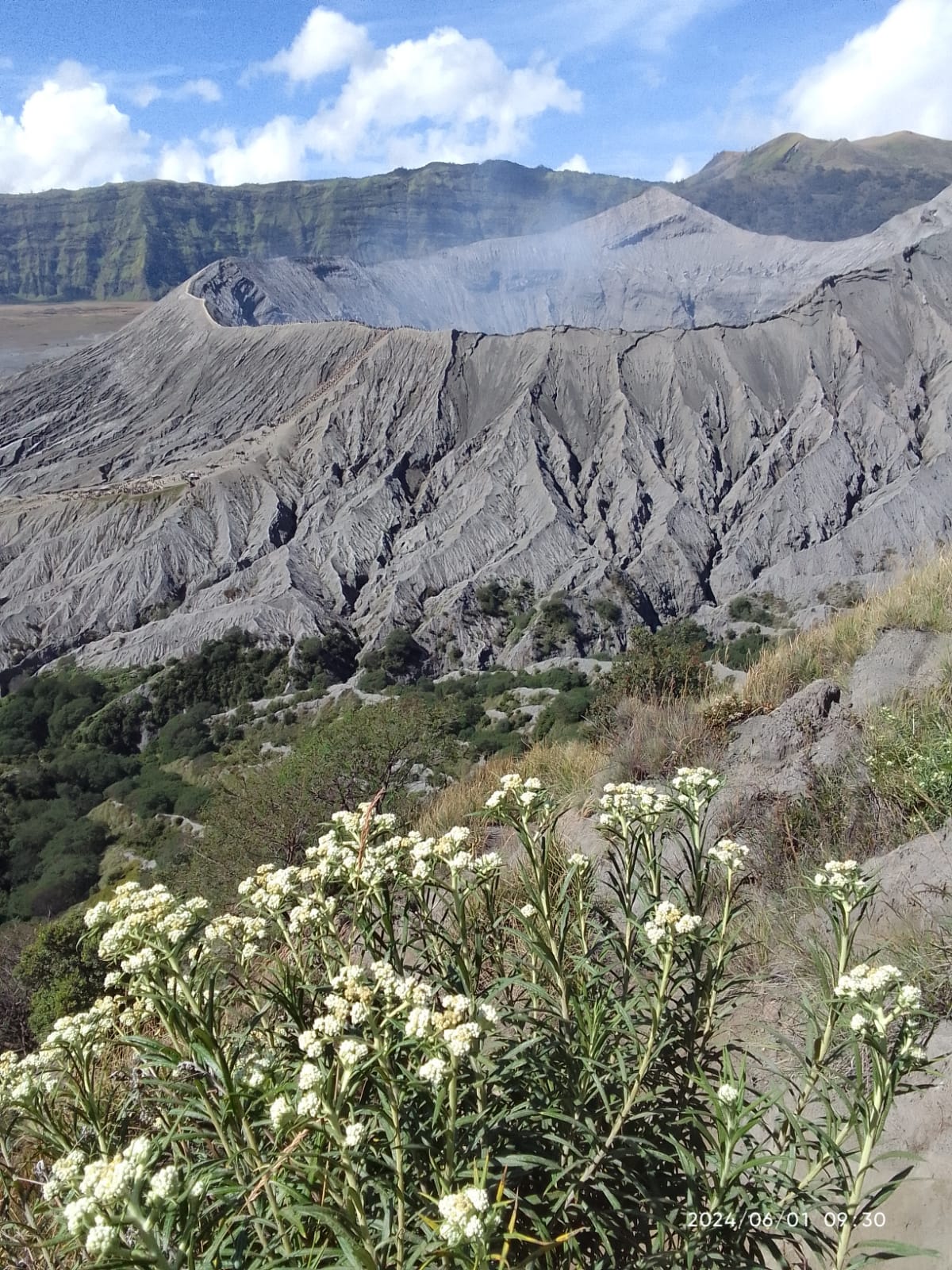
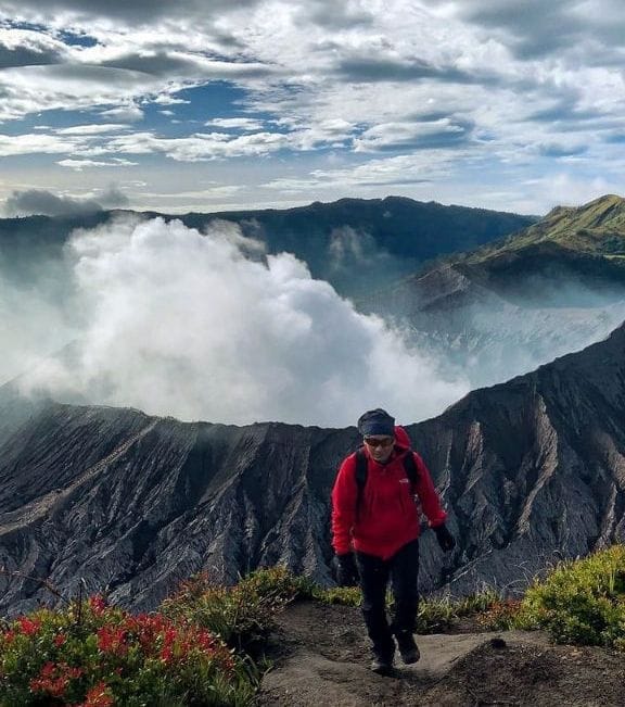
The topography of Mount Batok is physically demanding, characterized by incredibly steep incline angles frequently exceeding 45 degrees. Because Batok is a perfectly shaped stratovolcano, the ascent follows a relentless upward trajectory with very few flat switchbacks for resting. The terrain is entirely composed of loose volcanic dust, compacted ash, and dry gravel, which significantly reduces foot traction. Hikers will frequently experience a “two steps forward, one step back” sensation as the soft, sandy surface shifts under their boots.
The trail itself is narrow, etched deeply into the heavily eroded, corrugated ridges that run vertically down the mountain’s flanks. There is no vegetation canopy to provide shade; the path is entirely exposed to the elements, featuring only scattered scrub brush and hardy alpine grasses clinging to the harsh soil. Trekking poles are an absolute necessity here, as the lack of solid bedrock makes balancing precarious, especially when carrying heavy camera equipment. Despite the rigorous conditions, the trail is easily recognizable due to the deep grooves formed by decades of rainwater runoff and seasonal winds shaping the ash.
Read also: Bromo Hiking Routes: Ultimate Guide to Hiking Mount Bromo
How Long Does the Mount Batok Trekking Expedition Take?
A complete Mount Batok trekking expedition in Zone D takes exactly 7 hours from start to finish. This comprehensive timeline breaks down into a 1-hour approach across the Sea of Sand, a 2-hour strenuous ascent to the summit, a 2-hour dedicated photography session at the peak, and a 1-hour rapid descent, allowing a small buffer for resting.
Pacing is critical for this journey, especially considering the soft volcanic terrain that continuously saps lower-body energy. The initial 1-hour approach is a flat, scenic walk from the parking area directly to the mountain’s base. Once the climbing begins, the 2-hour ascent requires slow, deliberate pacing to manage heart rates on the extreme inclines. Upon reaching the 2,440-meter summit, allocating a full 2 hours is essential. This gives you ample time to rest, set up your gear, and wait for the shifting afternoon light to transition seamlessly into golden hour. Finally, the descent, while physically faster at roughly 1 hour, requires intense focus to safely navigate the steep, sliding gravel back to the caldera floor before darkness falls.
When Should You Leave Your Hotel for the Best Light?
To optimize your lighting window and avoid the punishing heat of the midday sun, you should leave your hotel in the Cemoro Lawang area at exactly 1:00 PM. The early afternoon departure ensures you are not exerting massive amounts of energy while the sun is at its absolute highest and most intense point. By initiating the flat Sea of Sand crossing at 1:30 PM, you will arrive at the base of Mount Batok just as the sun begins its initial descent.
Starting the vertical climb by 2:30 PM means you will reach the summit around 4:30 PM. This schedule is perfectly engineered for travel photographers. You will arrive exactly 45 minutes before peak golden hour, providing the precise amount of time needed to recover your breath, scout the absolute best vantage points along the rim, and secure your tripods before the sky ignites.
What Photography Gear Do You Need for Mount Batok?
Bringing the correct photography gear is vital because the climb’s physical demands mean you cannot afford to carry dead weight, yet the sweeping vistas require specific glass to capture properly. The dusty, windy environment of the Bromo caldera is notoriously harsh on camera sensors, so switching lenses at the summit must be done with extreme caution, ideally inside a protective bag.
Your primary workhorse will be a high-quality wide-angle lens to capture the immense scale of the Sea of Sand and the neighboring volcanic peaks. A sturdy but lightweight carbon-fiber tripod is non-negotiable for keeping your framing steady in the high-altitude winds during the fading light of sunset. Additionally, carrying lens blowers and microfiber cloths is essential to combat the relentless volcanic dust that will inevitably coat your equipment. Below is a detailed breakdown of the optimal gear setup for conquering Zone D.
| Gear Item | Recommended Specs / Focal Length | Landscape Photography Purpose |
|---|---|---|
| Wide-Angle Lens | 16-35mm f/2.8 or f/4 | Essential for capturing massive, sweeping panoramas of the entire caldera, Pura Luhur Poten, and the dramatic skies. |
| Telephoto Lens | 70-200mm f/4 | Perfect for compressing the landscape and isolating the deep, textured ridges of Mount Bromo and the smoking crater. |
| Carbon-Fiber Tripod | Lightweight, spiked feet | Crucial for stabilization in high winds during golden hour and for long exposures as light fades. |
| Circular Polarizer (CPL) | Matched to lens thread | Cuts through atmospheric haze, deepens the blue skies, and increases contrast in the volcanic ash. |
| Graduated ND Filter | 3-stop or 4-stop soft edge | Balances the extreme dynamic range between the bright sunset sky and the dark volcanic sand of the caldera floor. |
| Weather-Sealed Bag | Dust-proof, rain-cover included | Protects sensitive camera bodies and lenses from the highly abrasive, wind-blown volcanic dust during the trek. |
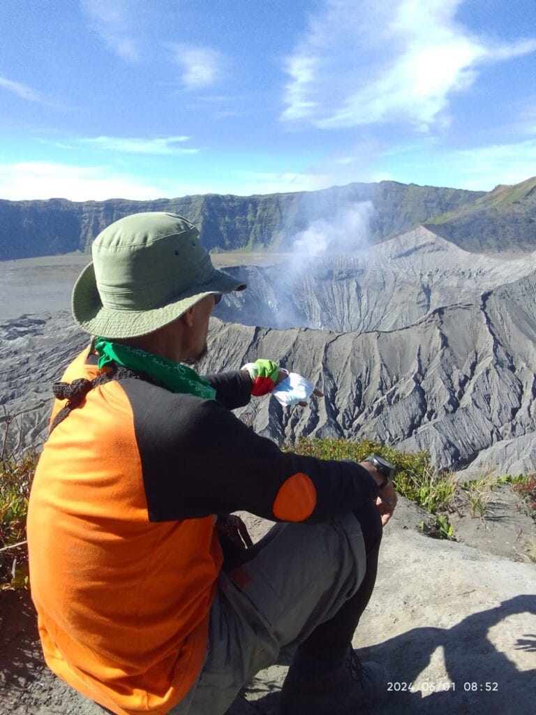
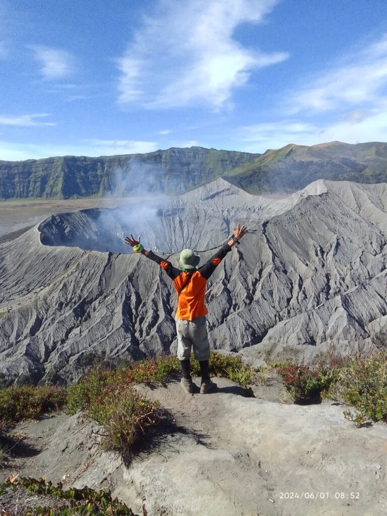
The primary photography spots at the Mount Batok summit are the southern ridge overlooking the active Bromo crater (7°56’30″S, 112°57’00″E), the eastern edge facing Pasir Berbisik (Sea of Sand), and the northern viewpoint framing Pura Luhur Poten. These vantage points guarantee unobstructed 360-degree panoramic views.
Reaching the 2,440-meter peak rewards you with highly distinct directional shooting zones. The southern rim provides an intimate, top-down perspective of Bromo’s smoldering caldera, allowing you to capture the raw geothermal power from above.
Moving to the eastern plateau allows photographers to capture the vast, textural expanse of the Tengger sand sea. The northern vantage point is particularly striking for architectural and landscape juxtaposition, isolating the dark, geometric structures of the Hindu temple against the sweeping, barren volcanic plains. Because Mount Batok stands independent from the main crater rim, you gain a complete shooting radius. This geographical isolation completely eliminates foreground clutter and provides clear sightlines to Mount Semeru in the background. It is the ultimate destination for capturing the immense scale of the Tengger caldera without the constant interference of tourist crowds typical of the Penanjakan viewpoints.
How to Capture the Bromo Caldera During Golden Hour?
Golden hour at Mount Batok completely transforms the Bromo caldera, demanding precise control over your exposure triangle to capture the sheer contrast. As the sun dips toward the western horizon, the low-angle light rakes across the corrugated, deeply grooved slopes of Batok and Bromo, heavily emphasizing the rugged volcanic textures.
To maximize this textural depth, shoot with a focal length between 24mm and 35mm, keeping your aperture tight at f/8 to f/11 for corner-to-corner sharpness. The dynamic range during this late afternoon window is extreme; the brightly lit sulfur plumes will heavily contrast against the deep, shadowed crevices of the caldera floor. Utilize a graduated neutral density (GND) filter or bracket your exposures to blend in post-processing. This ensures you retain detail in the shadow-heavy sea of sand without blowing out the highlights in the sky or the white smoke plume. Keep your ISO at base (100) to minimize noise, carefully adjusting your shutter speed to compensate as the ambient light rapidly diminishes over the terrain.
What Settings Work Best for Blue Hour Photography?
Once the sun drops below the horizon, the Tengger caldera enters blue hour, characterized by a cool, ethereal glow and deep contrast. This low-light environment requires immediate technical adjustments. Mount your camera on a sturdy tripod to eliminate shake, as your shutter speeds will drop significantly, often ranging from 2 to 15 seconds.
Open your aperture to f/4 or f/5.6 to gather more light while maintaining an adequate depth of field for the expansive landscape. You will need to incrementally bump your ISO to 400 or 800 to maintain optimal exposure without introducing excessive noise. Switch to manual focus and use live-view magnification on a distinct high-contrast edge, such as the rim of Mount Bromo, to ensure absolute sharpness, as autofocus systems frequently hunt and fail in the fading twilight.
How Do You Navigate the Descent from Mount Batok?
Descending Mount Batok is a drastically different experience from the strenuous ascent. While the climb takes roughly two hours, the descent is a rapid 1-hour maneuver back down to the caldera floor. The terrain on the downward slope consists primarily of deep, dry volcanic sand and loose scree.
Because twilight transitions quickly into total darkness after blue hour, navigating this stretch requires a high-lumen headlamp to read the terrain safely. You must continuously scan the path for hidden rocks beneath the powdery surface. Keep your center of gravity low and lean slightly backward to maintain balance on the steep gradients. Utilizing trekking poles is highly recommended to anchor your steps, maintain stability, and heavily reduce the intense impact on your knees as you navigate the shifting gravel.
Is Sliding Down the Volcanic Sand Safe?
Sliding down the volcanic sand—often referred to as scree surfing or plunge-stepping—is entirely safe when executed with proper technique. In fact, it is the most efficient and energy-saving method for tackling the steep, powdery sections of the Zone D trail.
To slide safely, plant your heels firmly into the deep sand with each step, allowing the momentum to carry you forward in a controlled glide. Keep your knees slightly bent to absorb the shock and use your trekking poles out in front of you as brakes. Avoid sections with large, embedded rocks, and stick strictly to the deep ash paths. High-cut trekking boots and gaiters are absolutely mandatory for this technique to prevent the sharp volcanic dust from filling your footwear.
Frequently Asked Questions About Mount Batok Trekking
Do You Need a Professional Guide for Zone D?
Yes. The Zone D trails are unmarked, prone to sudden shifts from wind erosion, and feature numerous deceptive branching paths. A professional guide ensures you navigate safely in the dark post-sunset and prevents you from walking into dangerous, unstable ravines on the descent.
What Is the Physical Fitness Requirement?
You need an intermediate to advanced level of cardiovascular stamina. The 7-hour continuous expedition involves a grueling two-hour ascent up a 45-degree incline of loose volcanic ash, demanding excellent leg strength and endurance. It is significantly more physically taxing than standard Bromo tours.
How Close Is the Active Bromo Crater?
Mount Batok sits immediately adjacent to Mount Bromo. Reaching the Batok summit provides a stunning, unobstructed bird’s-eye view directly into Bromo’s active, smoking crater. You are positioned roughly one kilometer away, offering a superior, elevated perspective compared to standing on Bromo’s own rim.
Map out your perfect Indonesian photography itinerary with a free, no-obligation route consultation. Contact us here