TL;DR — Key Facts at a Glance
- Best shooting window: 05:30–07:30 WIB (Western Indonesia Time)
- Top viewpoints: Canyon Rim Trail, Bamboo Ledge Platform, Lower Basin
- Drone status: Legal with a valid DGCA remote pilot certificate; pre-clearance required
- Peak season: May–September (dry season, low mist, maximum light clarity)
- Recommended focal range: 16–24mm wide-angle; telephoto rarely needed
- Essential gear: Weather-sealed body, ND filter kit, carbon-fibre tripod, waterproof bag
- Base camp: Lumajang, East Java — approximately 3 hours from Malang by road
Tumpak Sewu delivers its most powerful images between 05:30 and 07:30 WIB. During this window, directional light enters the gorge at a low angle. It separates the mist into distinct layers. Shadow and highlight coexist without blowing out. Our local guides have tested this window across every month of the year — and it holds consistently, season after season.
What Makes Tumpak Sewu a World-Class Photography Destination?
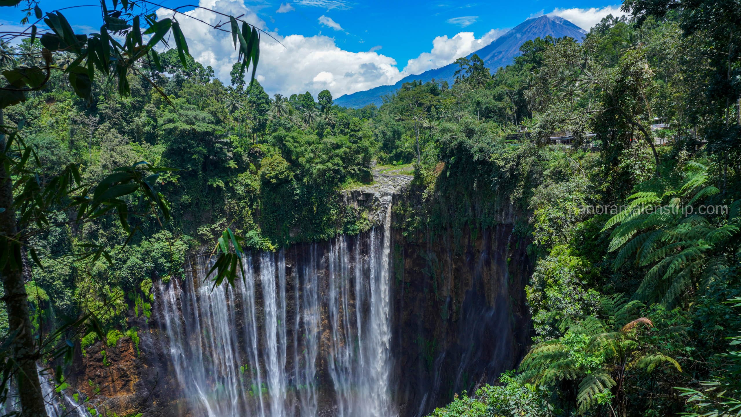
Tumpak Sewu is not a single waterfall. It is a curtain of water spanning roughly 120 metres in width and dropping approximately 120 metres into an enclosed jungle gorge. That combination — extreme width, extreme height, and a closed topographic bowl — creates conditions found nowhere else in Southeast Asia.
The gorge acts as a natural light well. Sunlight enters from a narrow aperture above. It refracts through layered mist before reaching the basin floor. This produces colour gradients and tonal depth that open-landscape waterfalls cannot replicate. For photographers working with wide-angle lenses and foreground interest, the compositional potential is exceptional.
Surrounding vegetation adds a secondary layer of visual richness. Ferns, moss, and bamboo grow to the gorge edge. They frame the curtain without obstruction. This means a strong foreground element is always available — which is one of the most difficult problems to solve at other waterfall locations in Indonesia.
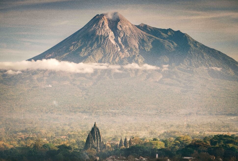
Furthermore, Tumpak Sewu sits within a short drive of Mount Bromo and Kawah Ijen. This makes it a natural anchor point for any serious East Java photography circuit.
When Is the Best Time of Day to Photograph Tumpak Sewu?
The ideal shooting window at Tumpak Sewu is 05:30–07:30 WIB. During this period, sunlight enters the gorge at a low, oblique angle. It illuminates the mist without flattening it. Shadows retain depth and texture. The exposure triangle remains manageable. By 08:15, overhead light degrades contrast rapidly, and the mist begins to thin.
To be precise: arrive at the Canyon Rim viewpoint no later than 05:20 WIB. This gives 10 minutes to set up a tripod and check your exposure settings before the first usable light enters the gorge. Our guides confirm that the single most common mistake among visiting photographers is arriving at 06:30 — one hour too late.
Why Does Golden Hour Behave Differently Inside a Gorge?
Inside an enclosed gorge, golden hour physics differ significantly from open-sky conditions. Above the treeline, golden hour produces warm, diffuse, directional light across a wide field. Inside Tumpak Sewu, that same light is funnelled, filtered, and scattered by the gorge walls before it reaches the basin.
The result is a colour temperature shift toward amber-magenta rather than pure gold. Mist acts as a natural diffuser. It softens harsh shadows and adds atmospheric haze to the mid-ground. Exposure compensation of +0.7 to +1.0 EV is typically required, because in-camera metering consistently underexposes the bright mist zone. Using a graduated ND filter helps balance the bright curtain against the darker gorge floor.
Is Blue Hour Worth the Extra Effort at Tumpak Sewu?
Most photography guides recommend golden hour as the primary window. That recommendation is correct — but incomplete. Blue hour at Tumpak Sewu, specifically the 05:00–05:30 WIB window before direct sunlight enters the gorge, produces a distinctly different and arguably more dramatic result.
During blue hour, the entire gorge sits in ambient twilight. There is no directional light to manage. This allows shutter speeds of 2–8 seconds without overexposure. The water motion renders as pure silk. The mist glows with a cool, blue-teal tonal range. The contrast between the white water and dark rock faces reaches its maximum. However, the descent trail to the lower viewpoints is near-invisible in pre-dawn darkness. A head torch, a physically confident pace, and a local guide who knows every root and step are non-negotiable requirements. For photographers willing to invest the preparation, blue hour at Tumpak Sewu produces images that no golden-hour shooter in the same location can replicate.
Picking the right time is a crucial things for photographers who demand perfection in each photo they take, this is important topic to know that’s why we’ve already wrote full guide to pick the right time to visit Tumpak Sewu. Learn more in: Best Time to Visit Tumpak Sewu for Perfect Light
How Does the Season Affect Morning Light Quality?
Season determines two variables at Tumpak Sewu: mist density and trail condition. Both have direct consequences for image quality and physical access. Neither is unconditionally better — they produce different results, and the right choice depends on the photographer’s stylistic intent.
| Season | Months | Mist Level | Light Quality | Trail Access | Recommended For |
|---|---|---|---|---|---|
| Dry | May–Sep | Low–Medium | High contrast, warm tones | Excellent | Landscape, drone, wide-angle |
| Wet | Oct–Apr | High | Soft, diffused, moody | Difficult | Long-exposure, atmospheric |
| Transitional | Apr & Oct | Variable | Unpredictable | Moderate | Advanced photographers |
The dry season (May–September) delivers the clearest curtain views. Mist levels are lower. Light penetrates deeper into the gorge. Colour saturation is higher. Drone clearance conditions are also more consistent during this period. The wet season (October–April) produces a thicker mist envelope. This limits clarity but enhances mood. Long-exposure shots gain a layered, painterly quality that dry-season conditions rarely produce. Transitional months — particularly April and October — carry the highest variance. On rare mornings, a phenomenon guides call the “magic mist” occurs: a dense, low-hanging fog layer sits at exactly the height of the waterfall mid-point, creating a two-zone composition with clear sky above and obscured basin below.
Where Are the Best Viewpoints for Tumpak Sewu Photography?
Three primary viewpoints define the complete Tumpak Sewu shooting circuit. The Canyon Rim Trail provides the full curtain panorama at eye level with the waterfall’s upper section. The Bamboo Ledge Platform offers mid-height framing with natural bamboo foreground texture. The Lower Basin positions the photographer inside the mist envelope — ideal for environmental portraits and ultra-wide compression of the curtain’s full height.
Each viewpoint demands different gear priorities, different arrival timing, and a different mental model of the composition. Visiting all three in a single morning is physically achievable. It requires a 04:45 WIB departure from Lumajang and a guide who knows the inter-viewpoint trail connections.
What Camera Settings Work Best at the Canyon Rim Viewpoint?
The Canyon Rim Trail sits at the gorge’s upper edge. It delivers an unobstructed horizontal view of the full waterfall curtain. At this position, the primary challenge is dynamic range — the bright curtain and the dark gorge floor can span 5–7 stops of light.
Recommended settings for the Canyon Rim during peak morning light:
- Aperture: f/8–f/11 for full-field sharpness across the curtain width
- Shutter speed: 1/2s–2s for silky water motion; faster than 1/30s freezes motion unattractively
- ISO: 100–200; raise only if cloud cover reduces ambient light below workable levels
- ND filter: 3-stop or 6-stop to achieve target shutter speeds in brightening light
- White balance: Set manually to 5,200K–5,600K to preserve warm tonal accuracy
A remote shutter release is strongly recommended. Gorge wind creates platform vibration. Even a well-locked tripod can introduce micro-blur at shutter speeds below 1s if the shutter button is pressed manually.
Also read: Tumpak Sewu Viewpoint vs Base: Which Is Better?
How Do You Access the Lower Basin Safely?
The Lower Basin is the most physically demanding and most visually immersive viewpoint at Tumpak Sewu. Descent requires approximately 45 minutes on a steep, rocky, permanently wet trail. The path includes rope-assisted sections. Footwear must be waterproof and grip-soled — sandals and trail runners are inadequate.
All gear must be packed in a waterproof bag or dry sack. Water spray from the falls begins approximately 200 metres before the basin floor. Cameras without weather sealing will sustain damage at this distance. Our Panorama Lens Trip guides assess trail condition each morning at 05:00 WIB before any client descends. Access is suspended on any day where overnight rainfall has made the rope sections unsafe.
What Are the Drone Laws for Flying at Tumpak Sewu?
Flying a drone at Tumpak Sewu is legal under Indonesian aviation authority regulations (DGCA/Ditjen Perhubungan Udara), provided the operator holds a valid remote pilot certificate and files a pre-flight plan. The waterfall site itself sits outside any designated no-fly zone. However, the flight approach corridor over Lumajang district requires advance clearance through the DGCA online portal. Operating without certification carries a fine and equipment confiscation.
Indonesia updated its drone regulations in 2022. All drones above 250 grams require registration and operator certification — regardless of the operator’s country of origin. Foreign pilots are not exempt. Certification obtained in Australia, the EU, the US, or the UAE is not automatically recognised. Indonesian DGCA certification must be obtained separately. Processing takes 5–7 business days from completed application submission.
How Do You Obtain a Drone Permit for Tumpak Sewu?
The DGCA drone certification process involves four steps. First, register your drone on the DGCA portal at droneid.dephub.go.id using your passport details and the drone’s serial number. Second, submit proof of valid drone insurance — this is mandatory and frequently overlooked by international visitors. Third, complete the DGCA online operator competency test (available in English). Fourth, file a specific flight plan for the Tumpak Sewu location, including your intended flight dates and GPS coordinates.
Required documentation:
- Valid passport (copy)
- Drone serial number and model specification
- Proof of third-party liability insurance
- Intended flight dates and GPS coordinates for Tumpak Sewu
Panorama Lens Trip manages the full permit process for all photography tour clients as a standard inclusion. The permit paperwork, insurance facilitation, and DGCA liaison are completed before the client departs for Indonesia. No client arrives on-site without a fully cleared flight status.
What Drone Equipment Produces the Best Aerial Shots Here?
The Tumpak Sewu gorge creates specific aerodynamic challenges. Updrafts from the waterfall base are consistent and strong. The enclosed gorge walls create turbulence unpredictable for small, lightweight drones. Wind resistance rated above Beaufort 4 (approximately 5.5–7.9 m/s) is the minimum acceptable specification for stable footage.
Recommended drone specifications for Tumpak Sewu:
- Sensor: 1-inch or larger for low-light gorge performance during blue hour and early golden hour
- Form factor: Foldable and compact — the trail descent to optimal launch positions is narrow
- Wind resistance: Minimum Beaufort 4; Beaufort 5 tolerance preferred
- Battery life: Minimum 25 minutes per charge; carry at least two batteries
- ND filter compatibility: Essential for managing bright water against dark gorge walls
What Photography Gear Should You Pack for Tumpak Sewu?
The Tumpak Sewu gorge environment demands weather-sealed camera bodies, a wide-angle prime or zoom in the 16–24mm range, a sturdy carbon-fibre tripod, and a multi-stop ND filter kit. Humidity inside the gorge regularly exceeds 90%. Silica gel packs and a waterproof camera bag are non-negotiable requirements, not optional accessories. Any gear not protected against sustained moisture exposure will be damaged before the session ends.
| Category | Recommended Spec | Why It Matters at Tumpak Sewu |
|---|---|---|
| Body | Weather-sealed full-frame or APS-C | Constant mist and spray exposure at all viewpoints |
| Lens | 16–24mm f/2.8 wide-angle | Captures full curtain width with foreground depth |
| Tripod | Carbon-fibre, 3-section, rated 8kg+ | Rocky, uneven basin terrain requires absolute stability |
| Filter | 6-stop + 10-stop ND | Long exposures in variable morning light conditions |
| Protection | Dry bag + silica gel × 4 packets | 90%+ humidity throughout the gorge environment |
| Drone | 1-inch sensor, foldable, Beaufort 4+ | Trail portability and low-light aerial performance |
| Footwear | Waterproof, grip-soled | Lower Basin trail is permanently wet and rope-assisted |
| Power | × 3 batteries + portable charger | Cold mist conditions accelerate battery drain by 30–40% |
Weight management matters significantly on this location. The Lower Basin descent is physically demanding. A full-frame body with a 70–200mm telephoto attached is an unnecessary burden. Prioritise lens versatility over focal range coverage.
Do You Need a Telephoto Lens at Tumpak Sewu?
The short answer is no — and bringing one creates more problems than it solves. The gorge compresses apparent distance significantly. What reads as a long way across the canyon is, in lens terms, already filling a 24mm frame at f/8. A telephoto isolates small sections of the curtain but loses the contextual scale that makes Tumpak Sewu images identifiable and impactful.
Specifically regarding long-exposure work in the basin: a telephoto lens at 2-second shutter speeds in gorge wind conditions produces consistent motion blur in the frame — not creative blur in the water, but destructive blur from lens vibration. A wider, shorter, lighter lens mounted low on a rigid tripod eliminates this problem entirely.
How Does Tumpak Sewu Compare to Other Indonesia Photography Locations?
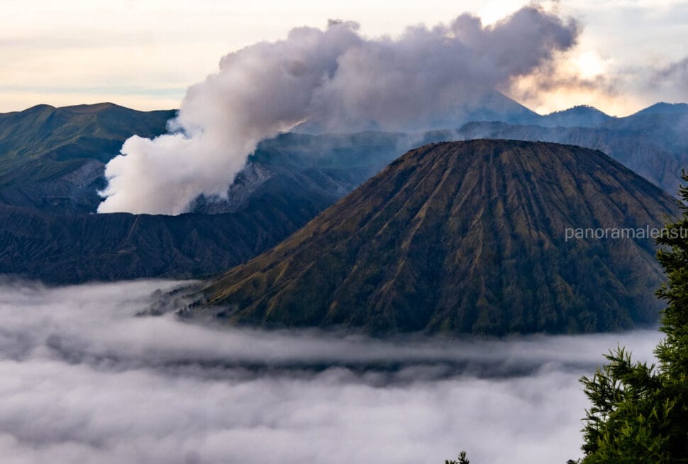
Tumpak Sewu is the highest-complexity waterfall shoot in East Java. It requires more technical preparation than Sekumpul in Bali or Madakaripura in the same province. In contrast, Mount Bromo and Kawah Ijen offer open-caldera compositions with longer and more forgiving golden-hour windows. This makes Bromo and Ijen better entry points for photographers new to Indonesia’s volcanic landscape, while Tumpak Sewu rewards those with prior experience in enclosed, dynamic light environments.
| Location | Best Light Window | Difficulty | Drone Access | Signature Shot |
|---|---|---|---|---|
| Tumpak Sewu | 05:30–07:30 WIB | High | Yes (DGCA permit) | Full curtain panorama in gorge mist |
| Mount Bromo | 04:30–06:30 WIB | Medium | Yes (DGCA permit) | Volcanic sea of sand at dawn |
| Kawah Ijen | 02:00–05:00 WIB | High | Restricted zone | Blue fire and sulphur crater |
| Sekumpul, Bali | 07:00–09:00 WIB | Medium | Yes (DGCA permit) | Multi-thread jungle cascade |
| Madakaripura | 06:00–08:00 WIB | Low–Medium | Limited clearance | Enclosed canyon walls, near-360° water |
| Rinjani, Lombok | Variable | Very High | Yes (permit) | Volcanic crater lake at altitude |
The East Java Photography Circuit — Tumpak Sewu, Bromo, and Kawah Ijen — represents the strongest concentration of world-class photography subjects within a 5-day itinerary anywhere in Indonesia. Adding Sekumpul in Bali extends the circuit to 7–8 days. Adding Rinjani in Lombok extends it to 10–12 days, with a significant increase in physical demand at altitude.
How Do You Plan a Multi-Destination Photography Itinerary Around Tumpak Sewu?
Tumpak Sewu pairs logistically with Mount Bromo and Kawah Ijen in a classic East Java Photography Circuit. A minimum of five days allows one full sunrise session at each location, with travel and rest days built in. Adding Bali’s Sekumpul or Lombok’s Rinjani extends the circuit to ten or twelve days without creating scheduling conflicts — provided drone permits for each location are filed simultaneously, not sequentially.
The logistical variable most photographers underestimate is permit lead time. DGCA clearance for multiple locations requires separate flight-plan filings per site. Each takes 5–7 business days. If permits are filed one at a time, the cumulative delay can exceed the planned trip duration. Filing all permits simultaneously before departure is the only practical solution. Furthermore, base camp selection between locations — specifically the Malang to Lumajang leg and the Lumajang to Bromo leg — involves pre-dawn road transfers that must be confirmed with drivers who know the mountain roads in darkness.
Map your complete East Java and Bali photography circuit — including pre-cleared drone permits for every location, sunrise positioning coordination, and exclusive local guide access — through a free, no-obligation route consultation with our field team. You arrive with a finalized itinerary. We handle every logistical variable between here and the gorge rim. Contact us now!
Frequently Asked Questions About Tumpak Sewu Photography
What is the best month to visit Tumpak Sewu for photography?
June and July are the peak months for Tumpak Sewu photography. Dry season conditions produce maximum light clarity, stable trail access, and reliable drone clearance windows. Mist levels are moderate — sufficient for atmospheric depth, but not so dense as to obscure the full curtain. Humidity is lower than the wet season, which extends usable shooting time and reduces gear risk.
Is Tumpak Sewu worth visiting without a drone?
Yes, unambiguously. Ground-level photography at Tumpak Sewu — from the Canyon Rim Trail, Bamboo Ledge Platform, and Lower Basin — produces images that aerial footage cannot replicate. The scale, foreground richness, and mist interaction from ground level are the defining characteristics of the location’s visual identity. Drone footage adds an aerial dimension; it does not replace the ground-level experience.
Can beginners photograph Tumpak Sewu independently?
The Canyon Rim Trail is accessible to beginners. The Lower Basin descent is not. Without a guide, inexperienced photographers consistently arrive too late, set up in suboptimal positions, and underexpose the mist zone. Furthermore, the pre-dawn trail to the rim viewpoint is unmarked in several sections. An experienced local guide eliminates all of these variables and is the single highest-return investment a visiting photographer can make at this location.
How far is Tumpak Sewu from Bali?
Tumpak Sewu is approximately 5–6 hours from Bali via the Banyuwangi ferry crossing, or 1 hour by domestic flight from Denpasar (DPS) to Malang (MLG) followed by a 3-hour road transfer. The domestic flight route is the standard choice for photography itineraries where time efficiency matters. Malang serves as the nearest major hub for onward ground transport to Lumajang.
What is the entrance fee at Tumpak Sewu?
The standard entrance fee at Tumpak Sewu is approximately IDR 20,000–25,000 per person for the Canyon Rim access. Lower Basin access carries an additional entry fee of approximately IDR 10,000. Drone launch fees are charged separately by the local site management authority and are distinct from the DGCA permit requirement. All fees are payable in cash (Indonesian Rupiah) at the entrance post. ATM access near the site is limited — carry sufficient cash from Lumajang.
How long does a full Tumpak Sewu photography session take?
A complete three-viewpoint session — Canyon Rim, Bamboo Ledge, Lower Basin — requires approximately 4–5 hours from first arrival to exit. Allow 45 minutes for the Lower Basin descent, 60–90 minutes for shooting in the basin, and 60 minutes for the ascent back to the rim. Factor in an additional 30 minutes for tripod setup, filter changes, and drone launch preparation at each viewpoint. Departing the site by 10:00–10:30 WIB ensures exit before the midday trail congestion from day-tripper groups.
Final Briefing: What to Confirm Before You Arrive at Tumpak Sewu
Preparation determines the quality of the session before the first frame is captured. The checklist below covers every variable our guides verify the evening before each client shoot:
- Drone permit status: Confirm DGCA clearance has been received and print a physical copy — not all site management staff accept digital permits
- Weather forecast: Check the 72-hour forecast for Lumajang district; rain the night before significantly impacts Lower Basin trail safety
- Gear waterproofing: Pack all camera bodies and lenses in dry bags the night before; do not repack at the trailhead in darkness
- Sunrise time: Verify the exact local sunrise time for your travel date — it varies by up to 25 minutes between May and September
- Battery charge: Charge all batteries to 100% the night before; cold mist conditions reduce effective battery life by 30–40%
- Memory cards: Format all cards and confirm available storage; a full-resolution 3-viewpoint session generates 400–600 raw files
- Guide confirmation: Confirm the morning meeting point and 04:45 WIB departure time the evening before
- Physical readiness: The Lower Basin descent requires stable knees and grip strength; assess honestly before committing to the full circuit
Tumpak Sewu does not forgive late arrivals, unprotected gear, or missed permit paperwork. Every logistical detail resolved before departure translates directly into creative freedom once the gorge light begins.